
Whether you’re a computer science student looking to expand your skillset into spatial technology or a geographer interested in statistics and programming, geospatial data science may be that unique degree you’re looking for.
But geospatial data science is still an emerging field, and degree programs remain relatively rare. There are just 25 geospatial data science programs at 22 schools across 17 states. They are almost evenly split by level, with nine master’s degrees, nine bachelor’s degrees, and seven certificate programs. And most programs are still rooted in traditional geospatial disciplines, with the majority housed in GIS, geography, or environmental science departments rather than standalone data science or computer science programs.
This guide breaks down the academic programs available in this discipline, the coursework to expect, and the careers these degrees can lead to. For a full list of geospatial data science programs, jump ahead to the end of the guide.
What Is Geospatial Data Science?
Geospatial data science encompasses the overlap between data science and geospatial technology. Its practitioners can simultaneously leverage programming, statistics, and geographic science to add location insights into workflows and deliverables. In an academic setting, students learn how to add, enhance, and prioritize spatial attribution in data to tell stories across space and time.
The discipline emerged at the beginning of the information and digital age as leaders in tech and business realized the immense wealth of data that would soon become available online. Experts began to automate search queries and calculations to extract insights and craft data-driven narratives. Simultaneously, geospatial technology was rapidly advancing, with geographers creating highly impactful data visualizations and analyses using location data.
Geospatial Data Science vs. GIS vs. Data Science
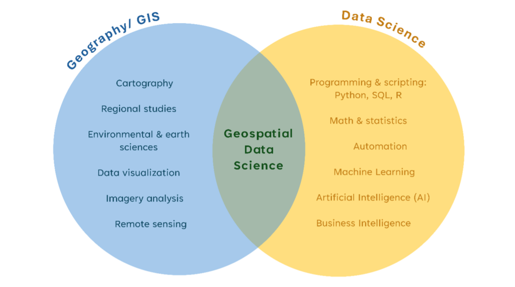
Distinct degree programs exist in data science, geographic information systems (GIS), and geospatial data science. Understanding the differences between these three subjects can be tricky. This Venn diagram sorts the key skills and disciplines of each field, with geospatial data science being where data science and GIS overlap:
Sometimes called spatial data science (or data science with an emphasis/concentration in GIS), this major may be the right one if you are interested in automating spatial problem-solving, developing interactive maps and data dashboards, and conducting large-scale statistical analysis with geographic data.
The field is distinct from GIS and data science because the coursework is highly specialized to prioritize both. Statistics courses that may be exclusively mathematical in a data science degree are configured to incorporate spatial distribution; on the flip side, geography and data visualization courses may include additional techniques in quantitative methods to enhance resulting maps. Professors may assume that students have knowledge in either physical geography or programming languages, which is why such degrees may have a long list of prerequisites.
Geospatial Data Science Education
Can You Earn a Degree in Geospatial Data Science?
Yes, more and more universities offer both bachelor’s and master’s degrees in geospatial data science (or in some cases, spatial data science). In fact, because of how rigorous this discipline is, and because it builds on the foundational knowledge from two different fields of study, master’s programs in geospatial data science are even more common than undergraduate programs.
Whereas GIS and data science degrees represent rather broad topics, geospatial data science focuses on developing a more specialized set of skills. Degree programs often allow students to customize learning methodologies by selecting from a wider range of electives to prioritize concentrations and applications. New software, both proprietary and open source, is continuously becoming available; universities have a duty to expose students to as many tools as possible to prepare for a career in the field.
The most common degree is geospatial data science, but other program names include:
- Spatial data science
- Environmental data science
- GIS degree with data science specialization
- Data science degree with GIS specialization
Emergence of GeoAI
Students can expect both bachelor’s and master’s programs to focus on GeoAI. From automating spatial models to animating complex geo-visualizations, applications for artificial intelligence will evolve in the immediate future. Academic institutions are expanding curricula to capture this phenomenon, which will inform the next generation of practitioners about responsibly integrating these tools into workflows. As more programming roles become automated, the computer science field can seem uncertain; however, learning how to appropriately leverage AI will become an invaluable skill. Plus, a niche specialty like geospatial data science may serve as a differentiator and a bridge between disciplines.
Online Geospatial Data Science Degrees
It is also important to note the availability of online geospatial data science master’s programs. Due to the nature of the discipline—highly computerized, digital, and internet-based—as well as the academic space at large, many geospatial data science courses are offered entirely online. From live broadcasts to recorded lectures, virtual classroom forums, and VPN access to campus servers, there are several ways for students to engage with the necessary learning material. Particularly with master’s programs, courses are often offered in the evenings to accommodate working professionals.
Almost half of the over 20 schools with relevant programs offer online geospatial data science degrees, all of them graduate degrees. At the moment, there are no online bachelor’s programs available. Notable graduate degrees include:
- University of Arizona: Online MS in GIS Technology with a Geospatial Data Science Emphasis
- University of Illinois: Online MS in CyberGIS and Geospatial Data Science
- Texas A&M University: Online MS in Geospatial Systems Engineering with the Geospatial Data Science and Analytics Track
The program directory at the bottom of this guide has a full list of online geospatial data science degrees available.
Master’s in Geospatial Data Science Programs
Coursework
Master’s programs in geospatial data science usually offer coursework in GIS (geography, mapmaking, remote sensing, and data visualization), as well as traditional data science (computer science, machine learning, statistical analysis, and automation). But geospatial data science is more than the sum of its parts. It is a unique curriculum emerging at the intersection of spatial statistics, big data management, automation of spatial models, and GeoAI.
Introductory coursework in these programs will vary depending on the students’ background. If you studied math, statistics, or computer science as an undergraduate, but don’t know much about GIS, you may get a crash course in spatial technology before diving deeper into multidimensional data science. A background in geography or remote sensing means a familiarity with data formats and spatial science terminology, but you may require an introductory lesson in programming and scripting.
Core coursework will likely include fundamentals in spatial data management, including understanding spatial databases, writing queries, and building models. From there, coursework can become more advanced, encompassing geo-visualization, satellite imagery, automation, and statistics.
Some programs even include concentrations or tracks that a student can use to develop their niche. Depending on the desired career field and chosen applications, electives can range from:
- Spatial science for public health: Mapping the spread of disease, including predictive analytics.
- Conservation or environmental GIS: Developing advanced models for identifying invasive or endangered species, deforestation, wildfire, or drought.
- Cloud and server GIS: Understanding software and internet architecture, particularly for storing and streaming dynamic geospatial data.
- Location intelligence for business: Generating leads and tracking sales across physical customer landscapes.
- Geospatial intelligence: Modeling military and defense strategies.
More subdisciplines are emerging all the time, and the applications of geospatial data science are continuing to expand. If you are particularly interested in a specific industry, consider applying to a university that also has strong course offerings in that associated discipline to pursue opportunities for cross-enrollment; for example, if you plan to pursue spatial science for public health, courses from the school of public health can be added to your core geospatial data science courses.
Additional Graduation Requirements
In addition to about 30 credit hours of coursework, most master’s programs culminate with a capstone project or thesis. This requirement is often offered instead of a large final exam, as geospatial data science is more of an applied field than a testable subject.
Such projects are a combination of research, geo-visualization, and software development that address a unique real-world problem. Some universities even pair students with business clients to provide an opportunity to practice partnerships and iterative project development.
Careers and Salaries in Geospatial Data Science
Geospatial data scientists inform important decisions by businesses and communities. Graduates are building models that, for example, map customer locations, analyze traffic volume, track the spread of diseases, and much more.
Salaries can range drastically for graduates from geospatial data science degree programs because students pursue such diverse careers. A data scientist title can fetch anywhere from $80,000 to $200,000 annually, whereas the average salary for a geographer or geospatial engineer hovers closer to $70,000.
Employer diversity also drives the salary disparity. Individuals with a geospatial data science education can pursue jobs in many sectors—from government to healthcare to environmental nonprofits—each of which offers a range of financial compensation packages.
Government and Military Jobs
If you’re interested in government and military applications of geospatial data science, there are many jobs in geospatial intelligence (GEOINT), including pattern recognition, change detection, and predictive analytics. These skills can also be applied to local government, since cities and counties need emergency response management and infrastructure planning. Geospatial data science informs resource distribution, budgeting, and hazard prevention around the world.
Corporate and Business Jobs
If more interested in corporate applications, there is no shortage of job opportunities here as well. Particularly with the incorporation of AI, businesses require experienced data scientists to analyze data and extract insights that will inform decision-making. When businesses need to open new brick-and-mortar locations or distribute products to retailers, they rely on geospatial data science to understand customer demographics and locations.
Nonprofit Jobs
Geospatial data scientists are also prevalent in the nonprofit sector, including healthcare and environmental conservation. These professionals are building dashboards and databases to inform the public about disease outbreaks, deforestation, pollution, and other hazards—all powered by the visualization of geospatial databases that responsibly display statistical distributions.
There are countless careers to be pursued after studying geospatial data science. With the evolving tech landscape, there are likely many more roles that will emerge. With the skills learned in these programs, you too can craft a unique and dynamic career!
All Schools with Geospatial Data Science Degree Programs
22 Schools Found
Arizona
University of Arizona
School of Geography, Development, and Environment
Tucson, Arizona
California
San Diego State University
Department of Geography
San Diego, California
University of Southern California
Spatial Sciences Institute
Los Angeles, California
Georgia
Georgia State University
College of Arts and Sciences
Atlanta, Georgia
University of North Georgia
College of Environmental and Spatial Analysis
Dahlonega, Georgia
Illinois
University of Illinois at Urbana-Champaign
Department of Geography & Geographic Information Science
Champaign, Illinois
Indiana
Purdue University
College of Agriculture
West Lafayette, Indiana
Kentucky
Murray State University
Department of Earth and Environmental Sciences
Murray, Kentucky
Maryland
University of Maryland-College Park
Department of Geographical Sciences
College Park, Maryland
Michigan
Michigan Technological University
College of Forest Resources and Environmental Science
Houghton, Michigan
University of Michigan-Ann Arbor
School for Environment and Sustainability
Ann Arbor, Michigan
Mississippi
Mississippi State University
Data Science Academic Institute
Mississippi State, Mississippi
Missouri
Northwest Missouri State University
Department of Mathematics and Statistics
Maryville, Missouri
University of Missouri-Columbia
MU Institute for Data Science and Informatics
Columbia, Missouri
New York
CUNY Hunter College
Department of Geography and Environmental Science
New York, New York
Oregon
University of Oregon
Department of Geography
Eugene, Oregon
Pennsylvania
Pennsylvania State University-World Campus
College of Earth and Mineral Sciences
University Park, Pennsylvania
Temple University
College of Liberal Arts
Philadelphia, Pennsylvania
South Carolina
College of Charleston
Department of Computer Science
Charleston, South Carolina
Texas
Texas A & M University-Corpus Christi
College of Engineering and Computer Science
Corpus Christi, Texas
Virginia
Old Dominion University
School of Data Science
Norfolk, Virginia
Washington
University of Washington-Seattle Campus
Department of Georgraphy
Seattle, Washington